Country Facts – Zimbabwe
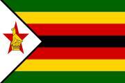
The Zimbabwe Flag
Green: Represents the farming and agriculture in Zimbabwe.
Yellow/Gold: Represents the abundance of mineral wealth.
Red: Represents the bloodshed during the first and second Chimurenga (wars of liberation).
Black: Represents the black majority.
White Triangle: Represents peace in Zimbabwe.
Zimbabwe Bird: Represents the National Emblem.
Red Star: Represents the nation's aspirations and hope for the future.
The Coat of Arms
The Coat of Arms depicts two kudus on either side, each standing on an earthly mound made of stalks of wheat, a pile of cotton, and a head of maize. Below them is a banner with Zimbabwe’s national motto: Unity, Freedom, Work.
The green shield features 14 alternating white and blue wavy lines at the top and, at its center, a representation of the ancient Kingdom of Great Zimbabwe. Behind the shield are an agricultural hoe (left) and an AK-47 automatic rifle (right), tied together with twisted strips of green and gold silk. On the crest, the red star and the Great Zimbabwe Bird (as on the flag) are shown.
Meaning of the Elements
- Kudus: Unity of Zimbabwe’s various ethnic groups
- Earthly Mound: The need to always provide for Zimbabweans
- Motto Banner: Emphasis on national unity and freedom
- Shield: Fertility of the country’s soil and water
- Great Zimbabwe: Historical heritage of the nation
- Hoe and Rifle: Celebration of the struggle for peace and democracy and the work ethic of the people
- Strips of Silk: Symbolize the national financial enterprise and economic protection
- Red Star: Hope for the future and the revolutionary achievement of majority rule
- Great Zimbabwe Bird: National identity
Country Profile
Map of Zimbabwe: Click here to navigate to the map of Zimbabwe on Google Maps
Climate
The country can be divided into three broad climatic regions:
- Central Plateau: Generally temperate.
- Zambezi Valley (Low-lying areas): Warmer and drier with hot summers.
- Eastern Highlands: Cooler with much higher year-round rainfall.
Summer rains (November to April) typically occur as brief, heavy downpours and thunderstorms, with daytime temperatures ranging from 25°C to the high 30s or even 40s in low areas.
Winter (May to August) brings lower temperatures and minimal rain; nights can drop below freezing, especially in the west. September and October are hot and dry as the rains approach.
Key Facts About Zimbabwe
Zimbabwe is an emerging economy in the Southern African Development Community (SADC) and COMESA regions, with high agricultural prospects and rich mineral resources. It offers opportunities in digital and knowledge-based industries supported by a robust ICT network, and a growing tourism sector anchored on world heritage sites.
Though landlocked, Zimbabwe has a well-developed road and rail network that provides easy access to sea ports in Maputo, Beira, Walvis Bay, and Durban.
Country Profile in Brief
Official Name: Republic of Zimbabwe
Main Cities/Towns: Bulawayo, Gweru, Mutare, Masvingo, Chinhoyi, Marondera, Bindura, Gwanda, Kwekwe, Hwange, Kadoma
Total Area: 390,757 km²
Land Surface Area: 386,670 km²
Population: Approximately 16 million
Literacy Rate: 92%
Official Languages: 16 official languages including English, Shona, and Ndebele
Religion: 84.1% Christianity, 4.5% Traditional Religion, 10.2% No Religion, 0.7% Islam, and 0.5% others (2017 ZIMSTATS)
Political System: Multi-party democratic system with separation of powers
Main Ports: Beira & Maputo (Mozambique), Durban (South Africa), Walvis Bay (Namibia), Dar es Salaam (Tanzania)
GDP Per Capita: US$3024 (World Bank, 2018)
Currency: Multicurrency system
Calling Code: +263
Internet TLD: .zw
Time Zone: GMT + 2 Hours
Major Export Partners: United Kingdom, China, South Africa, France, UAE, Belgium, Israel, Botswana, Mozambique, Namibia, Zambia
© 2025 Zimbabwe UN Mission. All Rights Reserved.


